

The map of the month for April 2021 features Santiago High School in Corona, CA. Orienteering USA president Clare Durand (LAOC) served as remote mapper for this project. The field checking was performed by the Santiago HS Air Force Junior Reserve Officer Training Corp (AFJROTC) cadets and instructors.
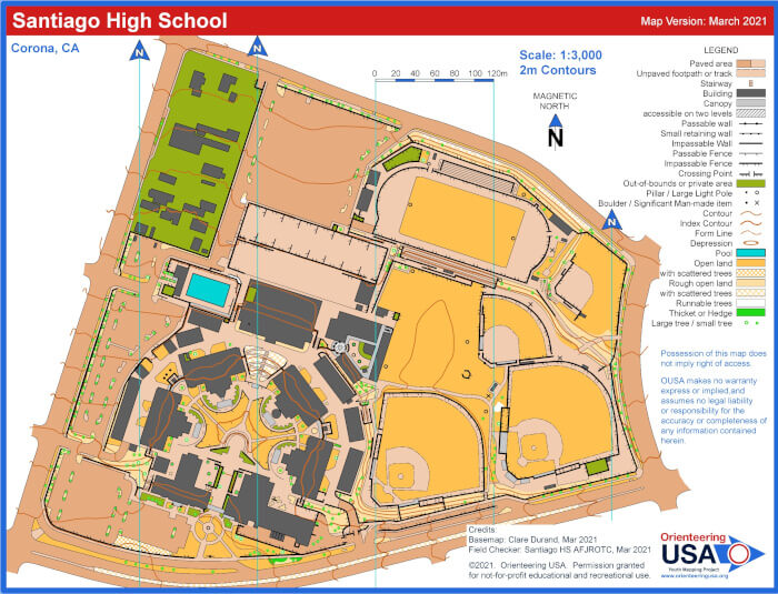
This project serves as an excellent example of the types of field checking questions prepared by the remote mapper (after the initial map drafting) and the responses returned by the remote field checkers. For this map the cadets reviewed the map areas in question and returned their response to Ms. Durand in only 3 days! This sort of team collaboration results in a very quick turnaround of maps in the YMP program. View the full map.
Some excerpts from the mappers notes followed by examples of the field checker responses:
(Download the complete response document here.)
General Notes on what to look for:
Safety – make sure any major items that affect the safety of participants are accurately represented on the map.
Stairs and Ramps – I found it difficult to tell where there was stairs vs just a ramp. Please check that I didn’t miss any important stairways.
Building/Canopy – Canopies are places where there is a roof, but you can walk underneath. I was able to identify some of this, but I imagine there are some that I couldn’t see. Please let me know if I have missed any significant canopy areas. If any architectural drawings exist that show the difference between the roofs and where the actual building walls are, that could be helpful.
Traffic Islands – some seemed to be dirt and others paved. Check that I got them right.
Vegetation – I mostly mapped trees with the smaller dot symbol because they seemed to mostly be smaller or else they were very tall palm trees with only a thin trunk near the ground. If any tree is noticeably larger and you want me to change the symbol just let me know.
Out-of-bounds – The private land in the NW corner is mapped olive green to show it’s out-of-bounds. I’ve also used this for some smaller areas in the campus where it seemed reasonable. This symbol can be used anyplace that you want to restrict runners from entering. Let me know if I’ve missed anything important.
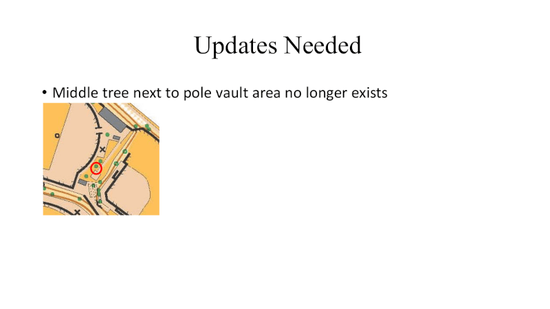
Specific questions. These areas are outlined in red and numbered on the map. Some numbers appear more than once.
- Could use some pictures of this area. I can’t determine what are the paths/ramps and what is not a travel path.
- Are gates generally open or shut? Should the fence continue across the driveways and/or sidewalks?
- Crossable or Uncrossable Fence? It looks like it might be easily crossable, but mapping as uncrossable makes it illegal to jump the fence.
- Dirt as yellow or as brown? Yellow would indicate an “open area” not normally used as a walking path. Brown would indicate a more regularly traveled area.
- Is there something here that should be mapped? I can’t tell what is there.
- Are these properly mapped as canopy? Are they closed wall on any side other than the backstop?
- Is the northern wall here an uncrossable wall or just a curb or low wall? I can’t tell under the trees what’s going on. Perhaps a picture of this area would be helpful.
- What are the details on these corridors? It looks like they are two floors with a stairway and maybe an elevator shaft? And then they open to the ground in opposite directions depending whether you are on top or bottom? Pictures would be helpful.
- Please check that I’ve interpreted this area correctly and that there aren’t any hidden features under the trees that should be mapped.
- Is it possible to get to this courtyard without entering a building? Perhaps via a canopied corridor either under the circular area or the SE building gap? If it is accessible to a runner, then I could use some pictures from inside the courtyard. I especially want to see the extent to which there is canopy around the edges. If it is not accessible, then don’t bother. Also will need picture(s) of the access points to map them properly.
- What is here? Is it worth mapping?
- Are storage containers permanently here? Should they be mapped?


Be sure to check out the Youth Mapping Program pages to find out more about how to get a map made for your school or youth organization as well as information on how to join the growing team of YMP mappers.