
Four Cases from JWOC and WOC – What Route Analysis Can Really Teach Us
More insight from orienteering coach Alex Azarov.
Introduction
The purpose of this article is to present my approach to route analysis. Using four real-life
examples, I will demonstrate the complete process: detecting a problem, finding the
underlying causes of the error, and developing specific training recommendations to prevent
it from happening again.
Two major international orienteering events recently took place: JWOC in Karlskrona,
Sweden, and the Sprint WOC in Genoa, Italy. In this article, I examine several mistakes made
by competitors in these races. Before turning to the examples, let us agree on a few basic
ideas.
First, losing time is not itself a mistake, and a mistake does not always cost time. Time loss
is evidence of a mistake – a symptom, not the cause. The purpose of route analysis is to
identify the underlying cause so that it can be addressed through training. This is often
difficult when analyzing the world’s best orienteers: their technical skills allow them to
navigate successfully even when their process is imperfect, so there may be no obvious time
loss (mistake manifestation). In many cases, the underlying mistake can be identified only
by talking with the athlete. Fortunately for our analysis, even the very best occasionally lose
time, and we can examine those cases.
Second, many orienteers classify mistakes as either “stupid” or worth analyzing. So-called
stupid mistakes are often dismissed. This is not very useful, because every mistake has a
cause. The aim is to identify that cause and then decide whether correcting it is worth the
training time. This approach helps us use training time more effectively.
With these principles in mind, let us begin.
Case #1 JWOC Long – Men
Let us look at the route of the men’s race winner, Matthieu Buehrer of Switzerland,
specifically the first part of leg 6 (see the map). What happened?
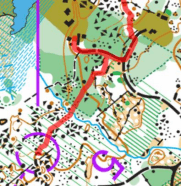
At first glance, this may look like a “stupid mistake”: he reached the road, failed to check his compass, and turned the wrong way. We might call it a random lapse and stop the analysis there. After all, accidents happen. But that explanation does not tell us what to train.
Question: Why did he turn left when he reached the road?
Answer: He believed he was to the right of the junction.
Question: Why did he believe that?
Answer: His plan was to reach the road somewhere to the right of the junction, but he failed
to maintain bearing.
This is where the analysis becomes more interesting. If this were an M16 competitor at a club
event, we might conclude that he needed to improve his compass technique and prescribe
standard bearing exercises. But we are analyzing route of the best junior in the world. In this
race and many others, he demonstrated that he could hold an accurate bearing in much
more complicated situations. The underlying problem was therefore probably not a lack of
compass skill.
My hypothesis is that he did not attempt to take a precise bearing at all. He simply aimed to
reach the road to the right of the junction. Because the road was impossible to miss, the
situation may have seemed too easy to require precision. He allowed himself to be vague –
and this time it cost him.
Orienteers often describe this as a “rough compass bearing” or simply “running in the
general direction.” It is worth mentioning that dividing one skill into “rough” and “precise”
versions has a drawback: it creates an extra decision point – does this situation require
precision, or is a rough direction good enough? Thus, it introduces just another potential
point of failure. That issue is not the main point here, however.
What does it mean to run on a compass bearing? It means following a straight line toward a
defined destination. A straight line connects two points. It cannot connect a point to a vague
area, or one vague area to another. I will never tire of repeating: if you want to get
“somewhere” you will end up “nowhere.” Conversely, when you define exactly where you
want to arrive, you are likely to reach close to that point. The key is intention: you must
choose a specific destination, and it doesn’t really matter how strongly you strive to reach it.
In this case, his objective appears to have been simply to reach the road “somewhere to the
right of the junction.” That is not a specific destination. Without a defined point to aim for, he
could not execute either a precise or a rough bearing in a meaningful way. Every bearing
requires a chosen endpoint, not a vague area.
We are not done yet! Look at the map. If you moved in the direction of the stone wall next to
control 5 you would come to the corner of the rough open area surrounded by stone wall.
That corner should be a very distinctive feature and easy to recognize when looking ahead.
Matthieu’s route suggests that he may not have read or used it.
So, in this section:
- He did not define exactly where he wanted to reach the road.
- He did not maintain a compass bearing.
- He did not read the relevant map features.
In other words, he used none of his skills/navigation tools on this section of the leg. He
clearly had the skills required to navigate there, but at that moment, he did not apply them.
This may reflect another misconception that is common among orienteers: the final
approach to a control feels important, while the exit from the previous control feels less
important. That is dangerous because it classifies features as important or unimportant
according to where they occur on the leg. In reality, a feature is important if it is necessary to
execute your route plan. A feature is unimportant if recognizing it would not affect your
navigation. Its importance depends on its role in the plan, not on its distance from the next
control.
I said “may” because we cannot know whether Matthieu agrees/follows this misconception
without speaking to him. Therefore, this interpretation should not be treated as a fact when
analyzing someone else’s route. When analyzing your own route, however, it is worth asking
yourself whether you consciously or unconsciously treat features near the control as more
important than features near the start of the leg.
This example shows how much we can learn from a so-called “stupid mistake.” More
importantly, once we identify the underlying causes, we can design specific training to
address them.
Case #2: JWOC O-Tour Stage 2 – H21, control 6
At first glance, this could also fall in a “stupid mistake” category (see the map). The
competitor simply failed to notice when he crossed the water ditch that he had planned to follow.
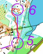
But this description does not tell us how to prevent the same mistake in the future. To identify the underlying cause, we should use the same approach as in the previous case and
keep asking “why?”
Question: Why did he fail to notice the water ditch when he was crossing it?
Answer: A ditch in marshy area is often barely visible. It may be difficult to follow while running alongside it and even harder to recognize when crossing it.
Look closely at the map. The planned route consists of two distinct sections: first, a compass bearing; second, following the water ditch. The runner therefore needed to change direction from one to another. Transition point is clearly identifiable: the corner of the green area, formed by a distinct vegetation boundary and the water ditch itself.
Had the competitor defined this corner as the turning point, he most likely would not have
missed it. Instead, his plan was only to run on a bearing, using nearby features for support,
and then follow the ditch. He did not define exactly where or when to switch from one
direction to the other.
This is like traveling on the subway without map: you know that you must transfer from the
red line to the blue line, but you have no idea on which station you should transfer and rely
only on the announcements. Missing the transfer is then quite likely – especially when the
announcements are difficult to hear.
Case #3: JWOC Relay – Women, leg 3, control 13
This was a dramatic moment on the final leg of the JWOC women’s relay. The Czech Republic
1 and Switzerland 1 teams were leading, about one minute ahead of their closest rivals, and
were fighting for gold. At control 13, however, both teams made the same mistake, lost a
large amount of time, and finished outside the medals.
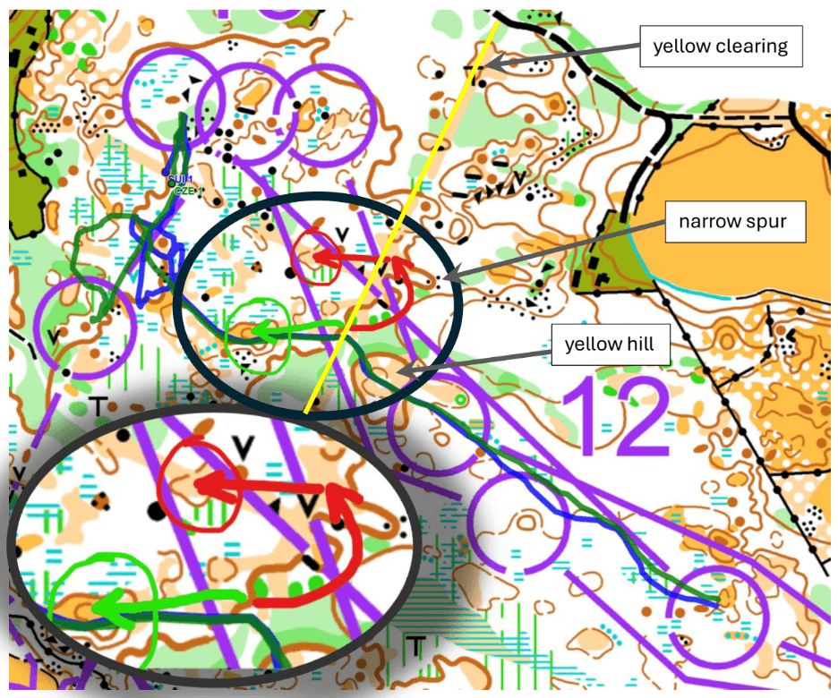
First, let us return to a point from the introduction: the amount of time lost does not
necessarily indicate how serious the underlying mistake was. Once a runner loses map
contact and must relocate, the final time loss depends mostly on luck – specifically, how
quickly the runner encounters a feature that can be identified with confidence.
So, what happened? After crossing the yellow clearing, they made left turn sharply changing
direction.
Question: Why did they change direction?
Answer: They saw a distinct feature – the yellow knoll marked by the end of the green arrow
on the map.
After passing that knoll, they changed direction again, this time turning right. After running a
short distance, they began looking for the control. Most likely, they had mistaken the
southern yellow knoll for the northern one marked by the end of the red arrow. In other words,
they believed they were in a parallel situation.
Question: Why did they confuse the two knolls? Why did they believe they were farther
north?
Answer:
The southern situation, shown by the green arrow, is preceded by a distinct open hill that
they should have noticed while crossing it. The northern situation, shown by the red arrow,
is preceded by a distinct narrow spur. Regardless of the exact point they intended to reach,
they should have recognized the difference if they had read these features from the map in
advance. This leaves two possible explanations.
- When leaving control 12, they may have aimed directly for the northern yellow knoll. They
may also have decided not to read the flat area between control 12 and the yellow clearing
in detail, which would have been reasonable because that section contains few distinct
features. Under this explanation, the main problem was inaccurate execution of the
compass bearing. They ran fairly straight, but at a small angle to the correct direction. The
appropriate training response would therefore be to practice compass bearing skill.
I consider this explanation less likely. The yellow knoll they would have been aiming for is
shown only by a form line, so it is not especially distinct on the map, and it lies beyond the
yellow clearing. The clearing forms a natural boundary between two different terrain types:
vague, mostly flat terrain before it and more detailed, bumpy terrain with many small
features after it. It acts almost like a wall that hides the features beyond it. If I were choosing
an intermediate target, I would choose a specific point on that boundary. I might then use
the yellow knoll for navigation only after crossing the clearing. - When leaving control 12, they may instead have aimed generally toward the area around
control 13 and studied only the final approach in detail (this strategy is known as
Attackpoints). This can make the features earlier on the leg seem vague and unimportant.
The runner knows that some features are present but has no clear picture of which ones to expect or in what order. The navigation process then becomes reactive: the runner reads a general “blob” from the map, notices a prominent feature in the terrain, and only afterward tries to match it to the map. The feature is identified retrospectively rather than anticipated.
When the runners saw the distinct yellow knoll on their left, at the end of the green arrow, they matched it to the northern yellow knoll at the end of the red arrow. Their approximate compass direction made that interpretation seem plausible. They did not immediately recognize the mismatch: in the northern situation, they should first have seen a narrow spur and shouldn’t have crossed a yellow hill, in southern situation, before reaching the clearing. Those differences are easy to miss unless the runner has already read them from the map and knows to look for them.
The central error, therefore, was that they were making sense of map based on surrounding terrain but should be making sense of surrounding terrain based on what they learned from the map. This is how the parallel error became possible.
This second explanation leads to two practical recommendations:
- When you are uncertain of your exact position – whether because of the original plan or
because you have begun to lose map contact – let the compass become your primary guide.
Under normal conditions, the map is primary and the compass supports it. Once you lose
map contact, those roles temporarily reverse. Your interpretation of the map may be wrong,
but the compass still indicates the correct direction. In this case, the runners should have
continued on the bearing toward the vicinity of control 13, their attack point, rather than
trying to identify a yellow knoll that they had not anticipated from the map. - As in case #1, make the plan specific. Choose a particular point that you aim to reach, and
while approaching it, read the map ahead so that you know which features should appear
and in what sequence.
One final point:
This happened near the end of the final leg of a World Champ relay. Two runners were
together, fighting for gold, under enormous psychological pressure. In that situation,
separating from the other runner is extremely difficult. A runner can confidently choose a
different direction only when they have 100% control of the navigation, know exactly where
they are, and can see that the rival is making an error. That requires a clear plan and
continuous map reading ahead. If either runner becomes vague about the plan or skips a
necessary action, such as reading details ahead, it becomes almost impossible to break
away from the tandem and navigate independently.
Running in a tandem is a skill of its own. Two or more runners often move faster together, but
this increased speed may come at the cost of lower technical quality. Some of the individual
decision-making disappears – route choices are no longer based entirely on each runner’s
own plan, but on an unspoken group agreement.
In this situation, each runner must redistribute their attention and devote part of their
attention to anticipating and tracking the “collective intelligence” decisions. Unfortunately,
many runners are not prepared for this shift. They increase their speed but do not adjust how
they distribute their attention. As a result, technical control becomes weaker, and the risk of
making a mistake increases significantly when running in a tandem.
Case #4: WOC Knock Out Semifinals – Women, control 5
Many people felt that the WOC Knockout Sprint courses were too complicated, even for Elite.
Let us look at control 5 in the semifinal (common for men and women):


In the first women’s semifinal, Lucie Dittrichova had spent about 50!! seconds rushing back
and forth across the square before she found a way through. In a mass-start sprint, this is an
enormous time loss. The route she eventually chose was also the longest option on the leg:
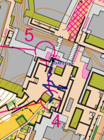
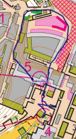
Was this a technical mistake? Not in the usual sense: she did not misread a feature or lose
contact with the map. Instead, she needed far too much time to identify the available routes,
and the route she finally selected was the least efficient one. I would classify this as a
tactical mistake. Tactics means Route choice.
- Her training may not have prepared her to identify the main route alternatives quickly on a
complex sprint map and then select the best one. In fact, it was a challenge for her just to
draw a continues line connecting two controls and she had to accept it because she, I guess,
didn’t see any alternatives. This is a specific skill that can be developed through route-choice
exercises: study complicated legs, identify all realistic options under time pressure, and
compare their length, complexity, and running speed. Obviously, if she had such training it
wasn’t enough.
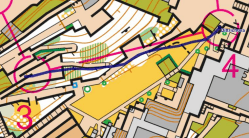
- Now look at the previous leg to control 4. It is simple both technically and physically. The
course setter effectively gave the runners an opportunity to study the complicated leg to control 5 in advance. However, from the TV broadcast, it appeared that therunners in this heat did not use that opportunity. I call this o-flow: the ability to redistribute efforts (mental and physical work) according to the situation, allowing in particular route choice on the previous leg during technically simple part of it. On a technically simple part, a runner can reduce the amount of attention devoted to immediate navigation and use some of that mental capacity to plan the next, more difficult leg. In this case, the route choice for control 5 could have been made before reaching control 4.
Conclusion
We have analyzed four cases in which elite orienteers made mistakes and developed
recommendations for avoiding similar errors in the future. The conclusions from each case
are useful on their own, but the analysis method itself is even more valuable. The following
step-by-step process can be applied to almost any route:
- Identify the place where the problem occurred. Time loss is often the visible sign of a
mistake, although not every mistake causes time loss. - Ask, “Why did it happen?”
- Develop one or more possible explanations.
- For each explanation, continue asking “why” until you reach a practical conclusion:
“Now I know what needs to be changed and how I can train it.” - Design training exercises or specific actions plan to correct the underlying problem.
This method can be used to analyze either your own routes or someone else’s. However,
analyzing your own routes can be even more efficient because you: - know where you felt uncertain, briefly lost contact with the map, or became lost but
relocated quickly enough to avoid an obvious time loss. In other words, you can
detect mistakes that are invisible in the split times or GPS track; - can answer the “why” questions more accurately because you know what you were
thinking and trying to do at the time. This reduces the need to consider several
possible explanations, as we had to do in Case #3.
I hope this article helps orienteers of all levels make their training more effective by analyzing
their own routes – and the routes of others – more systematically. If you have any questions,
please contact me at ogps007@nullhotmail.com.